Hurricane Beryl devastated the islands of Grenada on Tuesday and is now heading toward Jamaica and the Cayman Islands, breaking records as the earliest hurricane ever to reach Category 4 and 5 intensity in the Atlantic basin. Wind speeds of at least 160 miles per hour were recorded on Monday.
“Given the time of year, location and intensity, there are many superlatives to describe Hurricane Beryl,” said NOAA meteorologist and flight director Jonathan Zawislak. .
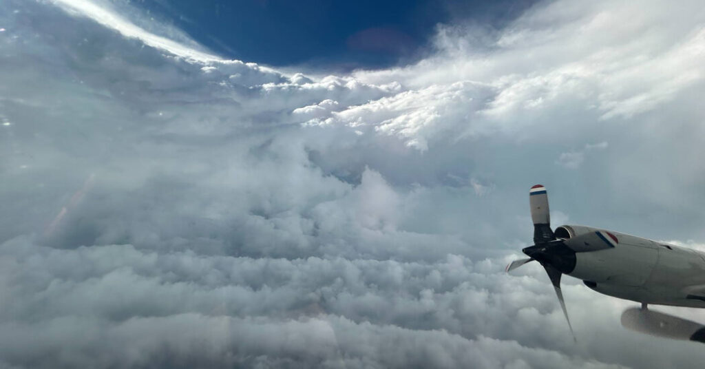
Dr. Zawislak is a hurricane hunter, a title held by some 30 to 40 scientists, data crunchers and pilots from Lakeland, Florida, who fly in three aircraft nicknamed “Gonzo” and “Kermit” ” and “Miss Piggy”’s plane flew into the hurricane. Kermit and Miss Piggy are equipped with Doppler radar on their bellies and tails, which scientists use to create 3D images of storms.
Over the past three days, Dr. Zawislak and his team flew through the rotating eyewall of Hurricane Beryl, flying from Kermit on St. Croix, one of the U.S. Virgin Islands. In a Category 4 or 5 storm like Beryl, the eyewall (the ring of thunderstorms, heavy rain, and dangerous winds surrounding the center of the storm) is loud and bumpy.
“It’s like being on a roller coaster at a car wash, except you don’t know when it’s going to go up or down, and you don’t know what the next turn is going to be,” Dr. Zavislak said Tuesday as he prepared for the third Beryl reconnaissance flight.
But there is calm in the eye of the storm. During daylight flights, Dr. Zawislak could look out of the bubble window at the back of the cockpit and see a bowl of quiet clouds with clear blue sky above.
His job was to navigate the chaos and find Kermit’s path as he flew between 8,000 and 10,000 feet while maintaining an airspeed of exactly 210 knots and flying the planes directly into the wind so they weren’t pushed around.
Jonathan Shannon, a spokesman for NOAA’s Aircraft Operations Center, said the goal of these flights is to provide better data to better respond to emergencies, especially when hurricanes change rapidly.
Since Dr. Zavislak’s first flight on Sunday, Hurricane Beryl has experienced rapid intensification, meaning its wind speeds increased by 35 miles per hour or more within 24 hours. Part of the change comes from the eyewall replacement cycle, or what Dr. Zawislak calls the “skater effect”: storm contraction, like a figure skater tightening her arms as she spins. The storm draws energy from the warm water, replacing old eyes with new ones and reorganizing its facades.
As Earth’s atmosphere heats up, more storms are experiencing this rapid intensification. A recent study suggests that Atlantic hurricanes are twice as likely to rapidly intensify, at least in part due to anthropogenic climate change caused by the burning of fossil fuels.
Hosmay Lopez, an oceanographer at NOAA’s Atlantic Oceanography and Meteorology Laboratory, said Beryl was a catastrophic start to the agency’s response to Atlantic hurricanes. The “most optimistic” forecast made by the season. The National Oceanic and Atmospheric Administration (NOAA) is predicting an above-normal hurricane season, with four to seven major storms and wind speeds exceeding 111 miles per hour.
The forecast is based on changes in the El Niño-Southern Oscillation, a natural climate pattern associated with warming conditions in the tropical Pacific, which is moving from a neutral state to La Niña. Calm conditions caused by La Niña, combined with unusually warm ocean temperatures, increase the potential for Atlantic hurricanes to form.
As they travel, hurricanes stir up the sea’s surface. They stir up cooler water from deep below the surface, which can dilute a storm’s energy, like stirring a cup of coffee to cool it down. But in addition to unusually warm sea surface temperatures that broke records for more than a year, temperatures deeper also were above normal.
“In this case, the coffee cup is very high, so even with strong winds, it would be difficult to mix the cold water from below,” Dr. Lopez said. Warmer temperatures at deeper depths allow storms to absorb more energy from the ocean, he said.
Hurricane season, which runs from June 1 to November 30, is traditionally quieter in June and July before resuming in August. Hurricane Beryl beat the previous record holder for a Category 5 storm, 2005’s Hurricane Emily, by about two weeks.

