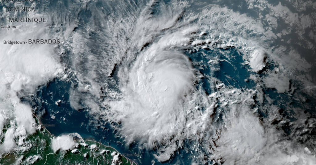
Tropical Storm Beryl, which officially became Hurricane Beryl on Saturday afternoon, is an unusual early-season storm that has been strengthening since forming late Friday night and forecasters warned it could intensify quickly.
The National Hurricane Center said Hurricane Beryl, the first hurricane of the 2024 season, is expected to bring “life-threatening winds and storm surge” to the Windward Islands southeast of Puerto Rico and northern Venezuela as it continues to move westward .
Forecasters said winds could increase by 30% in the higher elevations of the island.
A hurricane warning was issued for Barbados and several other Caribbean islands were under hurricane watches, including St. Lucia, St. Vincent and the Grenadines and Grenada. Martinique, Dominica and Tobago are under a tropical storm watch.
A hurricane warning means hurricane conditions are expected to develop in a designated area within 36 hours and people should complete all storm preparations, including evacuating when directed by local officials. A hurricane watch indicates the possibility of a hurricane within 48 hours and residents should be prepared to take action.
Forecasters predict Beryl will hit St Vincent and the Grenadines on Monday, with damaging winds likely to reach the capital Kingston at 8am local time.
Some computer weather models suggest the storm could intensify into a major Category 3 or higher hurricane.
According to NOAA records, only three storms in the North Atlantic reached Category 3 status early in the season: Alma in 1966, Audrey in 1957 and Unknown Storm in 1916.
All made landfall along the U.S. coastline in the Gulf of Mexico: Alma near St. Marks, Florida; Audrey near Port Arthur, Texas, and the 1916 storm near Mobile, Alabama.
Late Friday, the system became Tropical Storm Beryl, with sustained winds of 39 mph. When speeds reach 74 mph, a storm becomes a hurricane.
A named storm in the far eastern Atlantic is unusual for June, National Hurricane Center forecaster John Cangialosi wrote in a report Friday.
“Historically only a handful of storms have formed early in the year in the central or eastern tropical Atlantic,” he wrote.
Here is important information about the storm.
-
Forecasters say large waves generated by Beryl are expected to reach the Windward and Southern Leeward Islands late Sunday and could cause life-threatening waves and rip-off conditions.
-
The storm is expected to move across the eastern Caribbean islands as early as Sunday night and then through the central Caribbean by mid-week.
-
Eastern Caribbean islands including Barbados, St. Vincent and the Grenadines could see three to six inches of rain, hurricane-force winds and dangerous storm surges Sunday into Monday.
-
There is considerable uncertainty in forecasts about the storm’s track, especially three days out.
This hurricane season is expected to be busy.
Forecasters warn that the 2024 Atlantic hurricane season could be more active than usual.
In late May, the National Oceanic and Atmospheric Administration predicted there would be 17 to 25 named storms this year. The figure is “above normal” and the forecast is consistent with more than a dozen predictions made earlier this year by experts at universities, private companies and government agencies.
The average hurricane season produces 14 named storms.
The outlook for seasonal hurricanes is particularly aggressive because forecasters are seeing a combination of conditions at the start of the season that didn’t exist in records dating back to the mid-1800s: record warm water temperatures in the Atlantic and the potential for hurricanes to form.
La Niña occurs in the Pacific Ocean due to changes in ocean temperatures, and it affects weather patterns around the world.
When the winds are strong, it usually provides calm conditions in the Atlantic Ocean. This makes it easier for storms to develop and intensify without being disrupted by wind patterns that might otherwise prevent the storm from organizing.
John Yoonand John Keefe Contributed reporting.

